Saturday, October 13, 2012

Spray Park - Round 2

The first time I had heard about Spray Park was when Valerie went there on a cloudy day a few months ago. I had no idea what to expect, but my mind was definitely blown away.


A friend and I had planned to go on a hike somewhere off of Chinook Pass, but when we got to Enumclaw, there were hoardes of people talking about going to the same place. So we enacted plan B: head to Mowich Lake.
The road to Mowich Lake is not too bad, for the first few miles after the town of Carbonado. Then you hit dirt. Literally. It's about 13 miles of gravel road, filled with potholes. Not as bad as Middle Fork Road, mind you, but not exactly fun.


After getting a nice coating of dust on the car, we arrived at Mowich Lake, packed up our gear, then headed to Spray Park. The trail was nice and cool in the trees and it felt great to stretch my legs after that bumpy ride. We stopped at an overlook and I was blown away!

After the overlook, we continued on to Spray Falls. I loved how the falls weren't one big stream of water, but many small streams. I snapped a few pictures, then we headed on our way to the main attraction.


I had been so busy chatting and paying attention to the trail that I hadn't noticed where we ended up. I turned around, and WHAM! Mt. Rainier right in your face!


Look at those pictures! Isn't is so gorgeous!??!

After a quick snack and getting eaten alive by mosquitos, we headed up to the Hessong Rock - Mt. Pleasant Saddle. That trail was steep! It looked so long, but didn't take us that long to get up there.

Mount Pleasant
The view from up there was spectacular! You could see most of Spray Park with Mt. Rainier in the background.

Hessong Rock
We then hiked back down and headed back to the car. I was so tired but I still wanted to grab some shots of Mowich Lake before we left. It was super late when we got back, but I still had lots of fun.


Total time: 6 hours 
Distance: 7.5 miles, 1600 ft elevation gain (including side trip to Hessong-Pleasant Saddle)
Passes: Mt. Rainier entrance fee required
Location: Mowich Lake Trail head, GPS: N 46 55.978, W 121 51.833

Wednesday, October 10, 2012

Skyline Trail - Mt. Rainier

So in my previous trip report, I went exploring on the east side of Rainier on a Saturday, and now in this post, I am going to tell you about my hike on the west side of Rainier that occurred the next day.


Driving out to Rainier is no easy feat if you are coming from downtown Seattle. To get to either Sunrise or Paradise, it will take about 2.5 hours. Luckily for me, I live about an hour south of Seattle, so I shaved an hour off my time for both days!

Tina, Crystal and Dasha all met at my place early in the morning so we could meet the rest of our group at 9 in Puyallup (try saying that!). We stopped at Starbucks in South Hill while waiting for the others. I eventually got a call that they were at the Starbucks in the Fred Meyer while we were at the other Starbucks across the parking lot! Doh!


We met up, did introductions, then got on our way. The driving instructions to Paradise from where we were were pretty simple: turn right out of the parking lot, turn left when you get to the stop sign in Eatonville, turn left when you get to the stop sign at Alder, then follow the road into the park until you hit the parking lot! The only problem was it was about 20-30 minutes between each turn!


We got up to Paradise with no issues, other than a short wait at the gate to the park. The mountain looked gorgeous and the sun was out! I was really hoping to see a marmot snoozing on the snow. They are so cute!!!

The Skyline trail is a really popular trail, as we found out on our way up. The first two miles are up and up! (About 1400 ft in elevation) The last four miles are all down hill through gorgeous meadows.


There was still quite a bit of snow on the trail, but the flowers were blooming and it was just so gorgeous! The two guys in our group decided to slide down on their stomachs on some of the snow, with only t-shirts and shorts on! Ouch! (And no one got a video of it either!)

The snow slide. You can see their tracks!
 We hiked up to Panorama Point, which gives you a fantastic lunch spot, with views of the Tatoosh mountain range. We soaked in the views before making our long descent. I was surprised at how crowded it was up there!

Tina and I


As we followed the trail back down to the parking lot, we watched people practicing an ice axe arrest and other climbing skills. We also saw quite a few marmots! I was really hoping to see a marmot do this:

Photo by Ingunn from Trail Snail
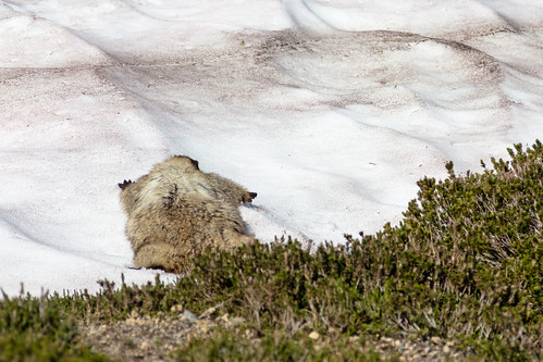
The only marmot I got a picture of. Still pretty cute!

We passed waterfalls and more meadows and more marmots. I was so happy to see three of those cute, fat, fluffy animals! I think I love them so much because they remind me of my cat, George, who is cute, fat and fluffy! And now here are lots of pretty pictures of  the meadows!


As we got back to the paved trail, there were more people, so we booked back to the cars. I really enjoyed this trail (except for the massive amounts of people at the end) because the views of Mt. Rainier were truly fantastic!


Back at Longmire, we stopped to take a look at this bridge over the Nisqually because it's just so cool looking! Overall, this was definitely one of my favorite hikes. Next time, I think I want to make it up to Pebble Creek, and eventually Camp Muir!


Total time: 4 hours 
Distance: 6 miles, 1400 ft
Passes: Mt. Rainier Entrance Fee or Annual Pass
Location: Paradise, Mt. Rainier

Thanks for reading!